Does a loop reconstruct more?
Compare occupied-voxel completeness under matched layouts and seeds.
A reproducible study of multi-view 3-D reconstruction, temporary traffic-control-device understanding, and failure-aware operational mapping for a mobile robot surveying an unfamiliar work-zone shape.
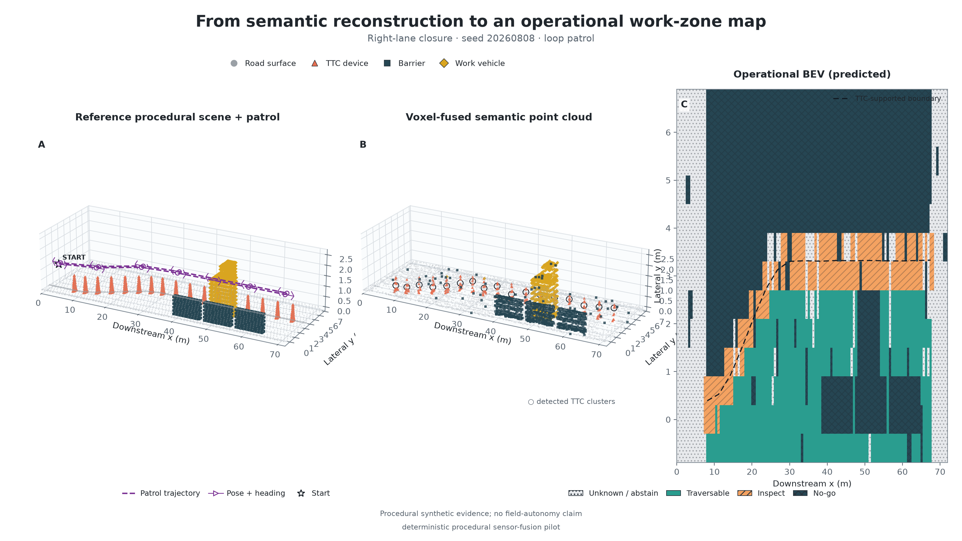
A road work zone may be straight, tapered, curved, or partially closed. A robot cannot safely treat an unfamiliar layout as an ordinary empty road. This pilot tests one bounded evidence chain: patrol the protected side, fuse repeated 3-D observations, recognize channelizing devices and obstacles, estimate only the device-supported boundary, then label observed cells as traversable, inspect, no-go, or unknown. Unknown remains an explicit outcome when the patrol has not supplied enough evidence.
The study compares a single scan, a one-way patrol, and an out-and-back loop on three illustrative boundary shapes and five fixed seeds. The implementation deliberately uses known poses so that this first test isolates viewpoint coverage, semantic fusion, boundary inference, and operational-map lowering. Localization error is reserved for the next experiment.
Compare occupied-voxel completeness under matched layouts and seeds.
Measure three-class actionable mIoU while counting unknown cells as misses.
Report the ground-truth no-go cells incorrectly labeled traversable as a separate failure metric.
Expose every layout–strategy cell instead of relying on one overall average.
Work-zone datasets, metric-semantic mapping, traversability estimation, and navigation masks are all relevant—but they answer different questions. The study keeps those layers separate.
| Primary source | What it contributes | What remains open here |
|---|---|---|
| WorkZone3D · WACV 2026 | Multimodal 3-D boxes for small work-zone channelizers and evidence for camera–LiDAR fusion. | Dense robot-centric reconstruction, traversability, and operational authority. |
| ROADWork · ICCV 2025 | Work-zone-specific recognition, scene interpretation, and video pathway prediction. | Dense 3-D ground truth for a mobile inspection patrol. |
| Kimera · ICRA 2020 / Voxblox · IROS 2017 | Metric-semantic meshes and distance-field mapping for planning. | Work-zone semantics do not themselves authorize a corridor. |
| STEP · RSS 2021 / TNS · RSS 2022 | Uncertainty-aware and construction-terrain traversability. | Temporary traffic-control policy near live traffic. |
| USDOT WZDx v4.2 / Nav2 Keepout Filter | Interoperable work-zone records and enforcement of a supplied keep-out mask. | Neither replaces local sensing or decides that an inferred mask is authoritative. |
The downloadable literature matrix contains 13 primary technical and government sources, their contribution to this design, and the claim each source does not support.
| Output state | Pilot rule | Deployment interpretation |
|---|---|---|
| TRAVERSABLE | Observed, boundary-supported road cell on the protected-side prior. | A mobility candidate; still subject to robot capability and approved corridor. |
| INSPECT | Observed cell near an inferred TTC boundary or detected device. | A perception target, not permission to manipulate the device. |
| NO-GO | Observed live-side road cell or directly observed obstacle buffer. | Must be fused with the approved TTC plan/supervisor constraints. |
| UNKNOWN | Insufficient observation or an unsupported TTC-boundary interval. | Abstain, collect another view, or request human review. |
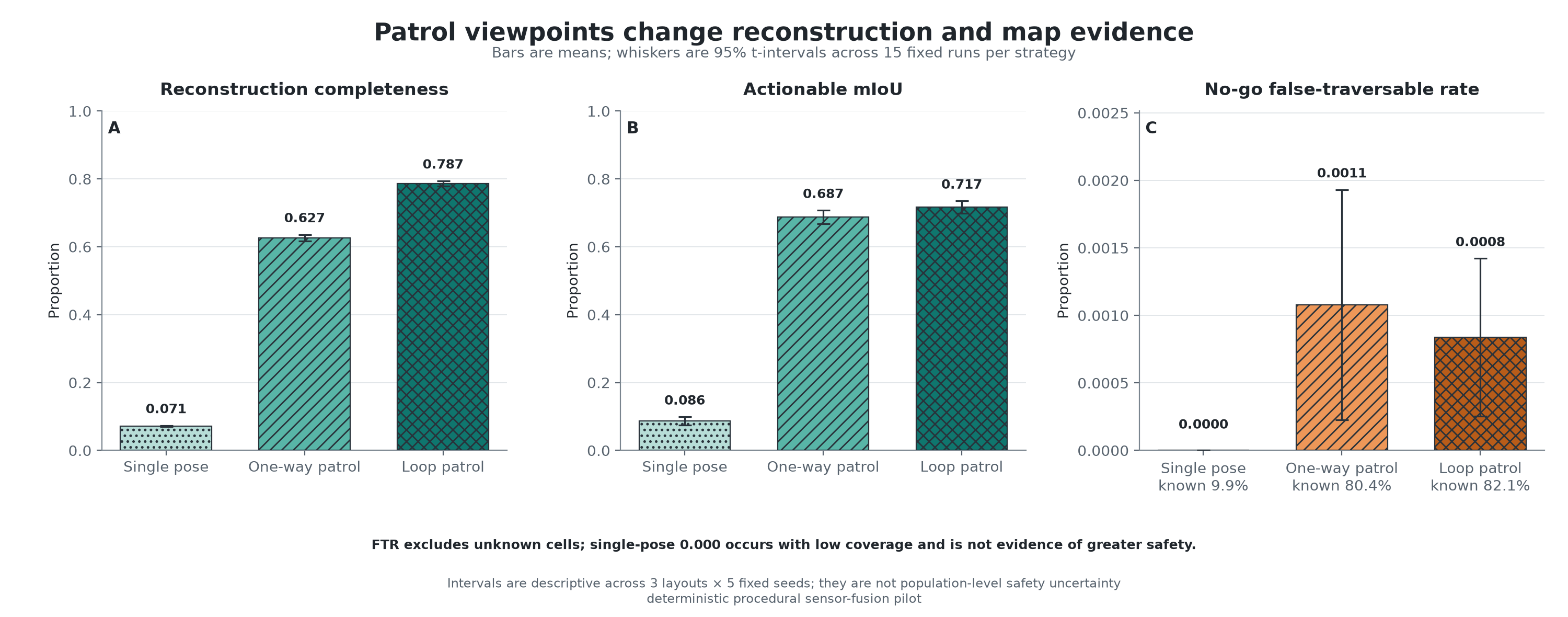
All numbers below are read from saved per-run evidence. No run was dropped. The intervals are descriptive 95% Student t-intervals across three layouts × five seeds, not population-level safety uncertainty.
| Patrol strategy | Completeness | Actionable mIoU | No-go → traversable | Known coverage | TTC precision / recall |
|---|---|---|---|---|---|
| Single pose | 7.1% [6.9, 7.3] | 0.086 [0.074, 0.099] | 0.000% [0.000, 0.000] | 9.9% [8.6, 11.2] | 100.0% / 23.6% |
| One-way patrol | 62.7% [61.7, 63.6] | 0.687 [0.667, 0.707] | 0.108% [0.023, 0.193] | 80.4% [78.7, 82.0] | 95.4% / 100.0% |
| Loop patrol | 78.7% [77.9, 79.4] | 0.717 [0.699, 0.735] | 0.084% [0.025, 0.142] | 82.1% [80.3, 83.9] | 98.5% / 100.0% |
Values are means; brackets are descriptive 95% t-intervals across 15 fixed runs, except TTC precision, which is the mean per-run auxiliary precision. Percentages are rounded for display; full precision remains in the downloadable CSV.
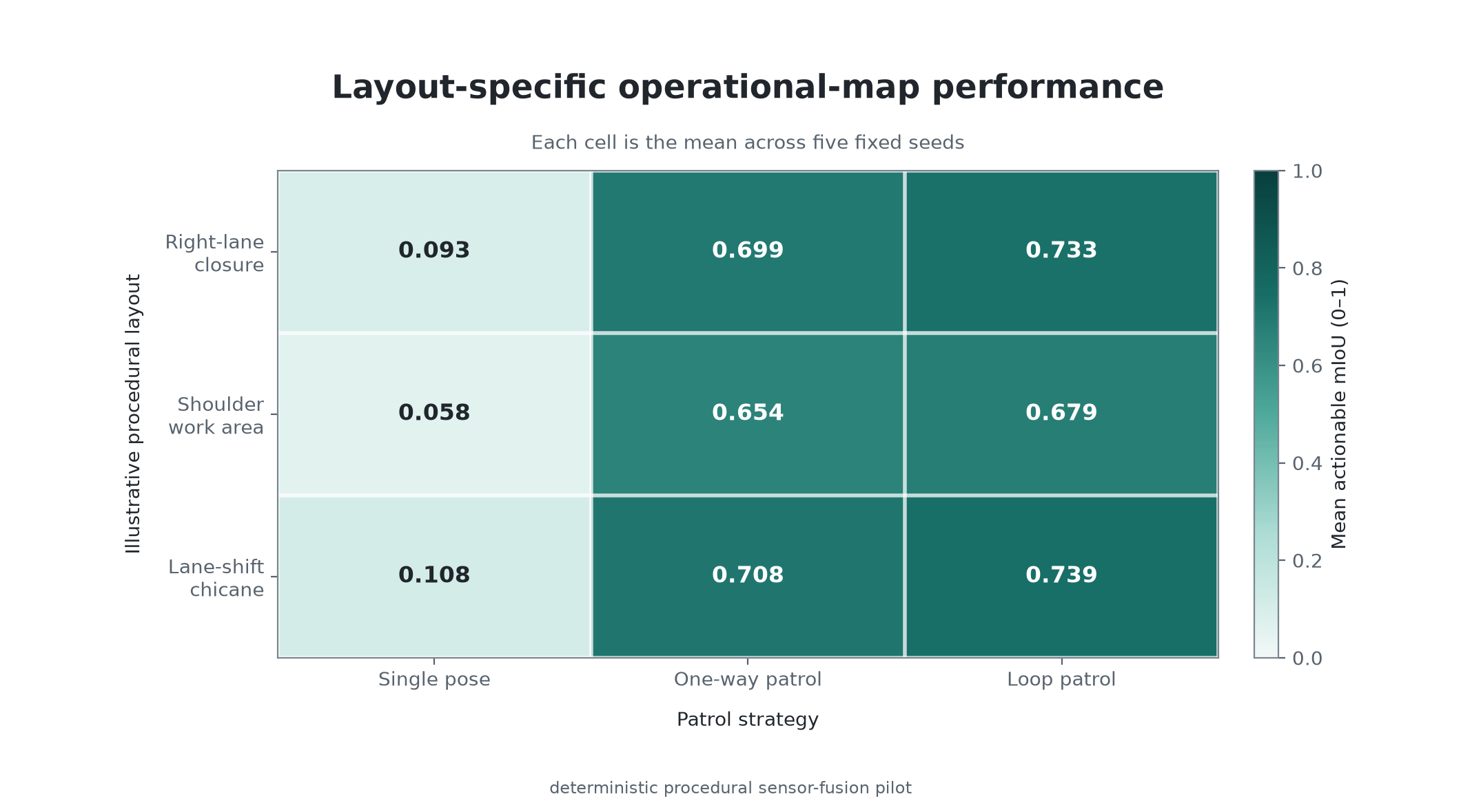
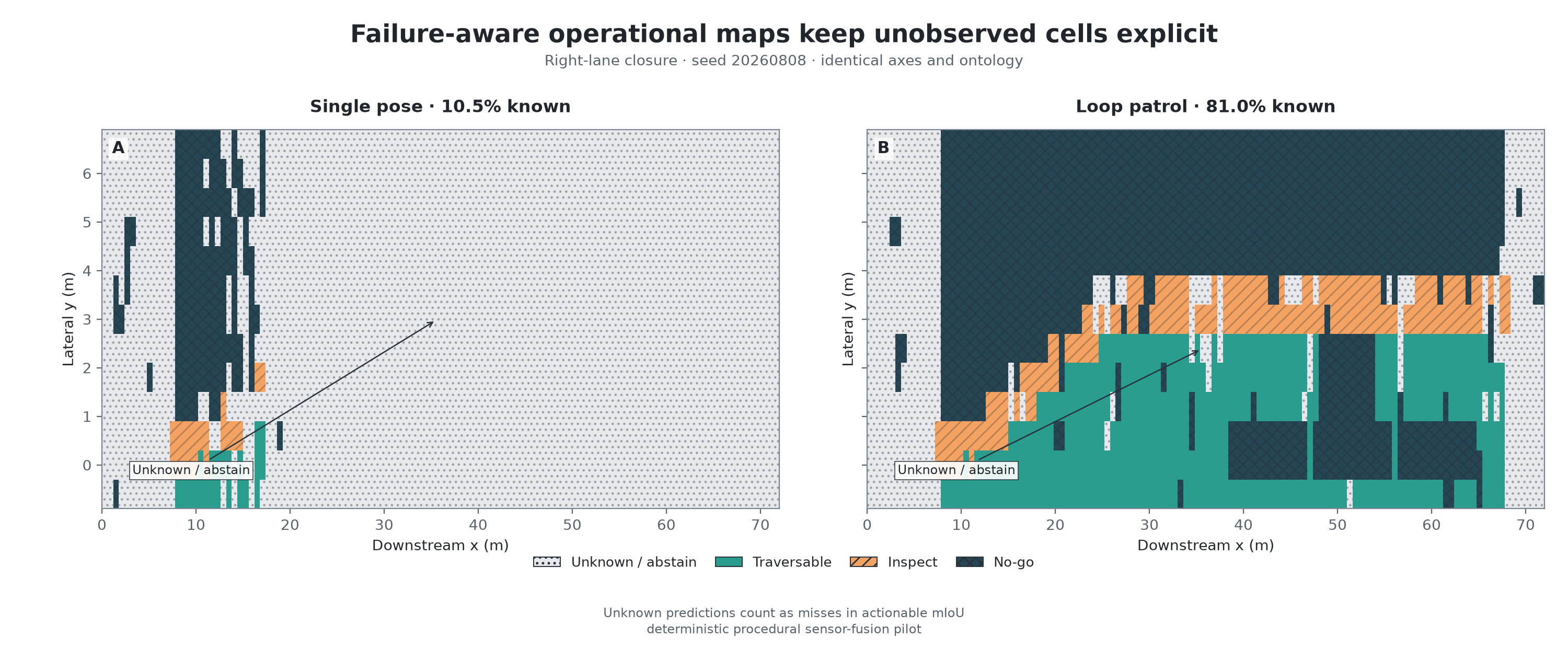
The return pass improved mean actionable mIoU over the one-way patrol in every tested layout: 0.733 for the right-lane closure, 0.679 for the shoulder work area, and 0.739 for the lane-shift chicane. The lower shoulder result remains visible rather than being hidden by the overall mean.
One-way and loop patrols both reached 100% mean TTC recall, but mean precision was 95.4% and 98.5%; some runs over-detected devices. The loop reduced mean boundary MAE from 0.116 m to 0.056 m relative to one-way. The single pose had a smaller 0.029 m MAE only over 14.4% mean boundary support, so the error cannot be read without coverage.
A cone boundary can be perceived, but perception alone cannot decide whether the robot is allowed on one side. The pilot freezes a protected-side coordinate prior so the inference can be scored. A real system must merge observed geometry and semantics with an approved temporary traffic-control plan, a site-supervisor corridor, or an equivalent authoritative source. That policy layer should override perception, and the navigation stack should preserve unknown space rather than convert uncertainty into permission.
| Gate | Input / change | Evidence required before the claim expands |
|---|---|---|
| 1 · CARLA oracle-pose capture | Ordinary LiDAR as algorithm input; semantic/instance sensors only for ground truth. | Registration, device recall, boundary error, map quality, manifests, and synchronized sensor provenance. |
| 2 · Pose uncertainty / SLAM | Injected pose noise, then LIO-SAM or equivalent estimated trajectories. | Absolute/relative trajectory error, map degradation, loop-closure failures, and runtime. |
| 3 · Domain shift | Lighting, weather, device type/layout, sensor placement, and unseen maps. | Calibration, failure taxonomy, abstention/coverage tradeoff, and held-out performance. |
| 4 · Controlled hardware | Robot or quadruped in a closed mock work zone under supervisor-defined keep-out policy. | Repeatable survey quality, safe-stop behavior, intervention rate, and independently reviewed operating procedure. |
The natural interface is a versioned SceneContract: coordinate frame, map hash, TTC detections, supported boundary, traversability layers, unknown mask, and authoritative corridor constraints. A model-checked route planner may consume that contract later. The present experiment does not implement natural-language mission planning or validate the reconstruction-to-planner handoff.
The package preserves the frozen protocol, literature matrix, executable notebook, per-run metrics, aggregate tables, configuration manifest, validation record, and representative arrays.
Software and dependency versions are recorded in the experiment manifest. Procedural artifacts may be reproduced; they are not substitutes for CARLA or field measurements.