ScholarMind AI
Research · Robotics · Transportation Safety

Evidence before claims.

We build reproducible prototypes for safer transportation work zones: public-data risk analysis, digital-twin inspection, change detection, and robotic restoration.

Evidence labels distinguish completed simulations from planned validation. Prototype results are not presented as field performance.
Read the 12-use-case priority study →

Completed evidence

Every result below has a source table or fixed-seed script, an explicit scope statement, and a next validation gate.

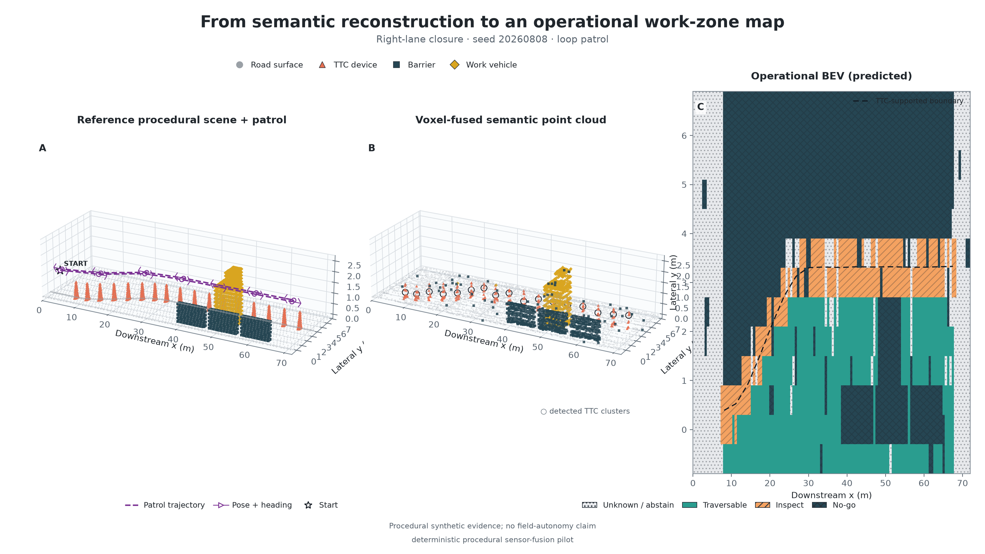
Robot loop patrol, fused semantic 3D point cloud, and uncertainty-aware operational work-zone map
PROCEDURAL SENSOR-FUSION PILOT · EXTENDED ABSTRACT

From a robot patrol to a semantic work-zone digital twin

45 fixed runs: the loop patrol achieved 78.7% mean reconstruction completeness, 0.717 actionable mIoU, and 82.1% known coverage.

The known-pose procedural study fuses multi-view 3D observations, detects temporary traffic-control devices, infers only supported boundary segments, and preserves unknown space. Its preregistered false-traversable-rate expectation was not supported; the single-pose zero occurred with only 9.9% known coverage. CARLA, SLAM, and hardware remain separate validation gates.

Read the Extended Abstract →
Executed notebook · truth-isolated prediction/audit artifacts · 11/11 validation checks · 11 unit tests

PUBLIC-DATA VIDEO · REPRODUCIBLE · EDGE TTS

Which hazards should inspection robots address first?

NIOSH: 650 of 1,462 road-construction-site occupational fatalities (2011–2022) involved a worker struck by a vehicle in a work zone. BLS: 48 in 2023 and 61 in 2024 for the comparable OIICS-v3 event.

The video separates evidence from inference: 44% is the composition of recorded fatalities—not a robot-priority score—and 48 to 61 is a one-year increase, not proof of a long-term trend. It then identifies candidate tasks that could reduce worker time near moving vehicles, with manipulation limited to protected access and controlled validation.

English Edge TTS narration · 62.8 seconds · Burned-in English captions + selectable WebVTT · Sources: NIOSH/CFOI and BLS CFOI Table 2 · Analysis snapshot: August 2026

CARLA 0.9.15 · COMPLETED DEMO

Right-lane closure taper and displaced device

Fourteen real CARLA construction-cone actors form an illustrative right-lane closure: nine cones taper from the outside shoulder to the lane boundary and five continue along the closed-lane tangent. One downstream cone is seeded 1.35 m into the adjacent live lane for change-detection testing. This is a research visualization—not an approved traffic-control plan or a 3D-reconstruction result.

Rendered on RTX PRO 4500 · 180 frames · fixed 0.05 s simulation step · scene manifest retained

KINEMATIC SIMULATION · REPRODUCIBLE

Restoring a displaced cone in a closed-lane taper

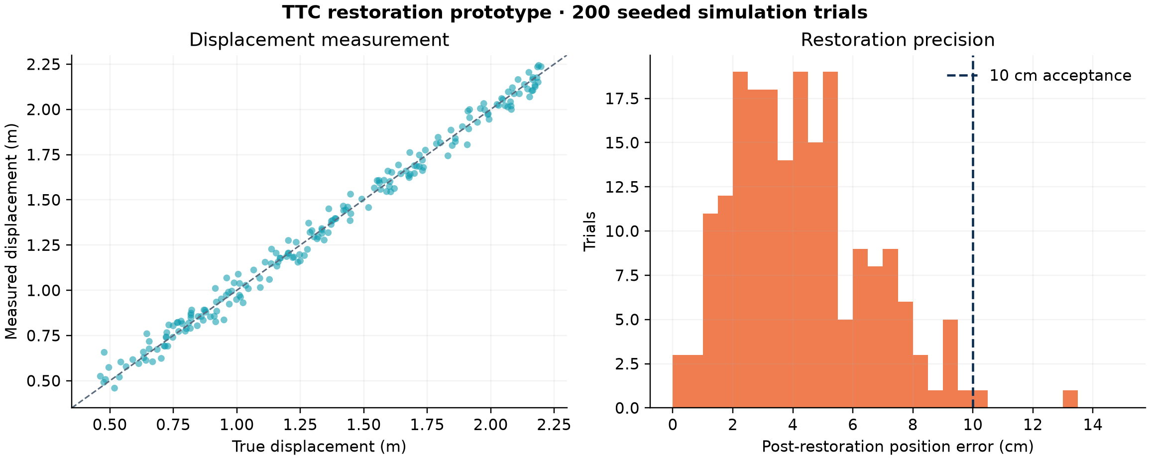
100% anomaly identification; 99% restored within 10 cm in 200 seeded trials.

Traffic flows left to right through the same four-lane right-closure geometry. The cone is displaced inward into the protected work area, and the restoration agent remains within the closed lane. Conditions remain simulated: 0.45–2.20 m displacement and 4.5 cm localization noise; grasp failures, live traffic, terrain, and hardware dynamics are not modeled.

Restoration simulation benchmark charts
BENCHMARK · 200 TRIALS

Measured against an explicit acceptance criterion

Median post-restoration error was 4.1 cm; the registered acceptance threshold was 10 cm. Trial-level CSV results and generation code are retained with the proposal evidence package.

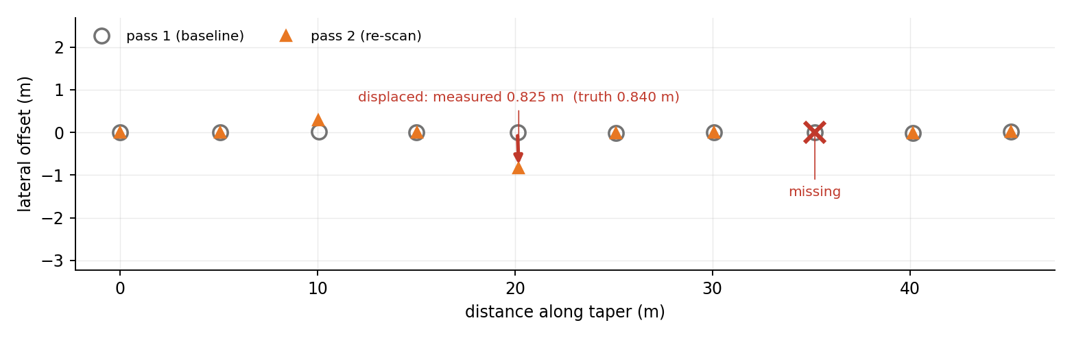
Two-pass LiDAR change detection: baseline and re-scan device positions with one displaced and one missing device flagged
CARLA 0.9.15 · MEASURED RESULT · FIXED SEED

Two-pass change detection recovers a 0.84 m displacement to within 15 mm

Displaced device measured at 0.825 m against 0.840 m ground truth; removal flagged; seven undisturbed devices moved 0.000–0.027 m — no false positives at a 0.30 m gate.

Ten channelizing devices in a simulated lane closure were scanned from a four-station patrol, perturbed (one displaced, one removed, one toppled), and rescanned; association between passes is purely geometric. The registered failure is reported, not tuned away: the toppled device shifted its centroid only 0.274 m — below the gate — so centroid-only tests miss topples, motivating a height/orientation feature. Device points come from the simulator's semantic channel, so this validates the matching stage, not the detector.

64-channel simulated LiDAR · 2 cm ranging noise · RTX PRO 4500 · preliminary evidence for a university-led USDOT DOT Bots Challenge Stage I concept paper currently in preparation (not yet submitted; August 2026)

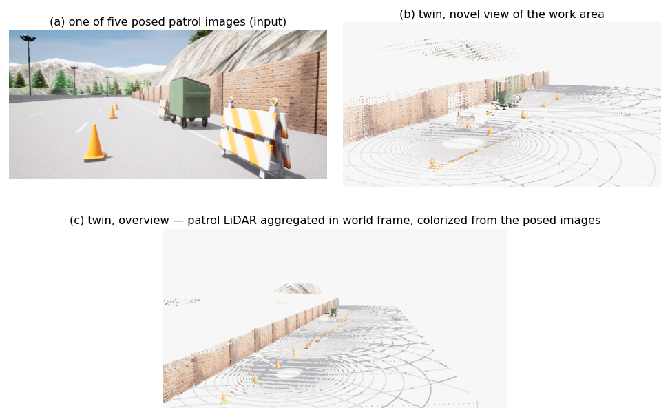
LiDAR-anchored colorized digital twin: posed patrol image and two novel views of the aggregated colorized point cloud
RIGID AGGREGATION · KNOWN POSES · COMPLETED

LiDAR-anchored colorized twin from a six-station patrol

118,235 points after 6 cm voxelization; 75,784 colorized from five posed patrol images; devices, barricades, equipment, and the retaining wall all metrically placed.

Patrol LiDAR is aggregated in the world frame at known poses and colorized by z-buffered projection of posed RGB — a deliberately rigid baseline for the twin. This is not joint optimization: the registered next gate upgrades it to LiDAR-anchored Gaussian-splatting reconstruction with joint pose refinement, following recent methods that initialize splats from LiDAR and refine camera poses against it. The staged closure itself was audited from a bird's-eye view for MUTCD plausibility (advance sign, shoulder-to-lane-line merging taper, tangent line, barricaded work area) before capture.

CARLA 0.9.15 · six LiDAR stations inside the protected corridor · five posed cameras · scene manifest and generation scripts retained

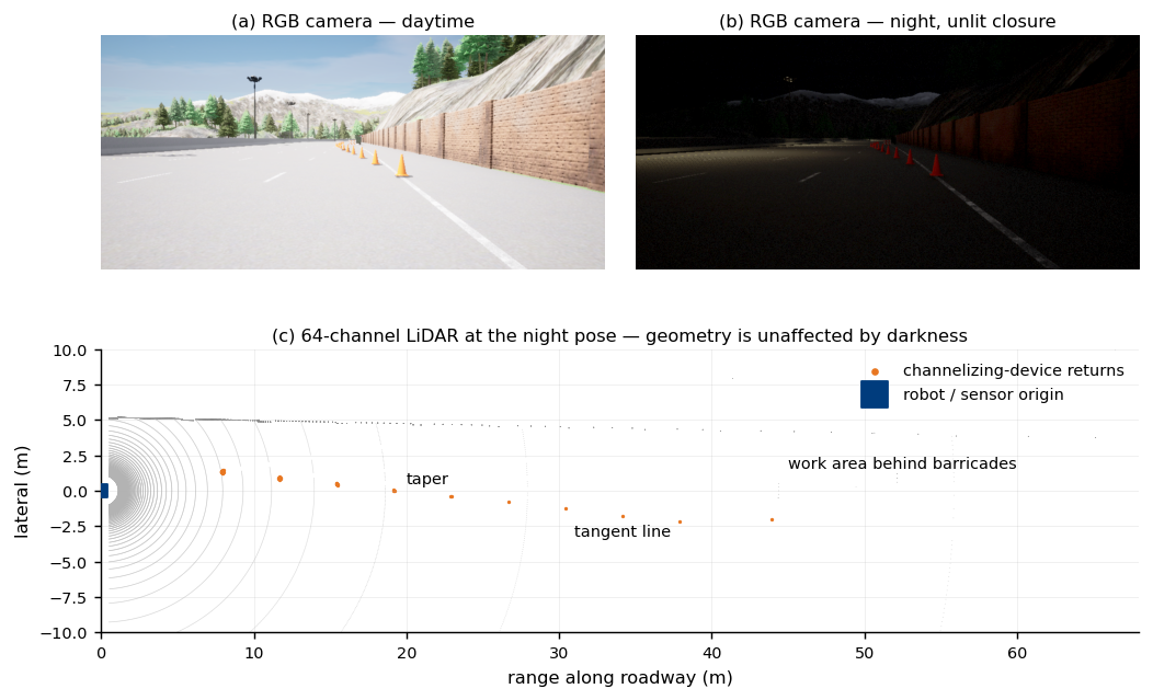
Same work zone by day, at night, and as seen by LiDAR at the night pose
SENSOR RATIONALE · COMPLETED DEMO

Why the payload carries LiDAR and cameras: night is the hard case

The same closure imaged by day and at night in an unlit work zone, plus the 64-channel LiDAR return at the night pose: the camera loses the far devices to darkness while LiDAR geometry is unchanged, since it supplies its own illumination. Cameras remain necessary for colour, legend, and lit-status information that geometry cannot provide. Simulated LiDAR omits retroreflective and wet-surface effects; field validation remains a separate gate.

CARLA 0.9.15 · identical pose day/night · supports unattended night-patrol feasibility, when worker and traffic exposure is lowest

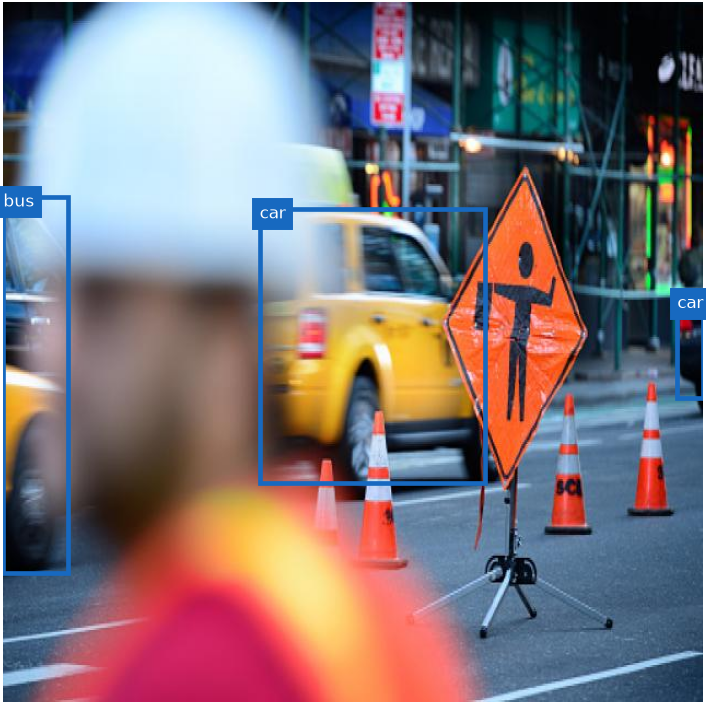
Baseline object detection without cone labels
Baseline detector
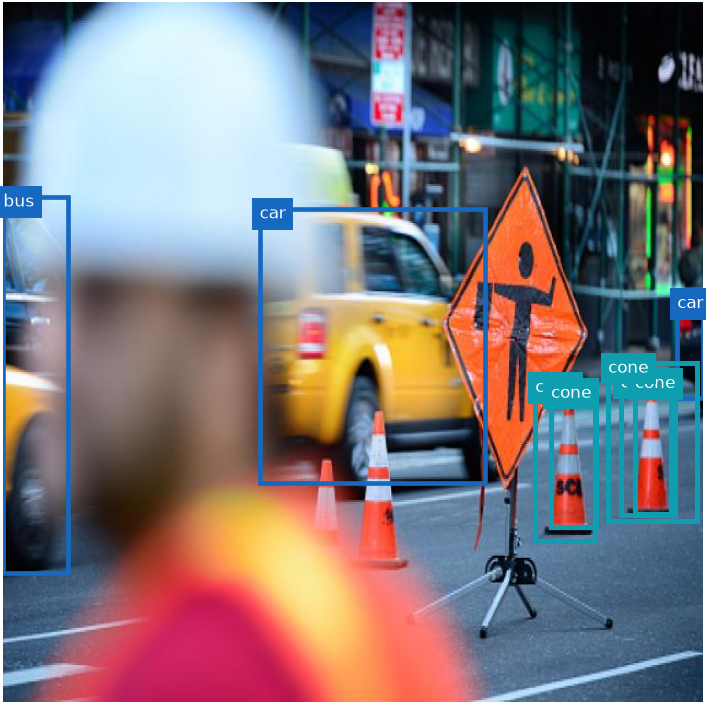
Detector with added traffic-cone labels
Task-adapted detector
QUALITATIVE PILOT

Task-specific cone perception

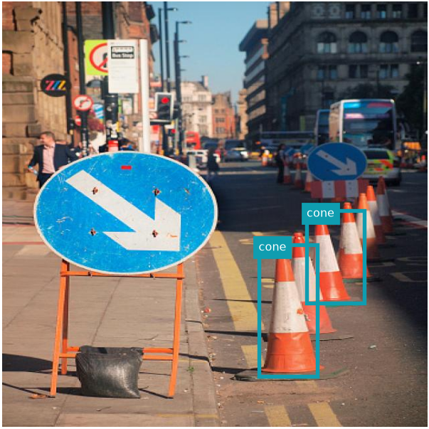
Qualitative before/after evidence shows the role of task-specific labels. A held-out, licensed benchmark with precision, recall, and mAP remains the publication gate.

Traffic cone detections in a real street image
REAL-IMAGE PILOT

Transfer beyond simulation

Real street imagery is used as a domain-shift sanity check. The current image is demonstration evidence only; dataset provenance and quantitative evaluation are required before reporting model performance.

Registered next experiments

These cards are protocols, not completed claims. Publishing the distinction keeps the portfolio credible while making the research trajectory concrete.

NEXT GATE

CARLA oracle-pose reconstruction

Use ordinary LiDAR as the algorithm input and reserve semantic/instance sensors for ground truth. Report registration, device recall/precision, boundary error, coverage, and synchronized provenance.

NEXT GATE

Pose uncertainty and SLAM robustness

Inject controlled pose error, then compare oracle poses with LIO-SAM or an equivalent estimator across lighting, weather, layout, and unseen-map shifts.

DOWNSTREAM PROTOCOL

SceneContract → model-checked planning

Transfer a versioned map, uncertainty mask, device boundary, and supervisor-approved corridor into a separately verified planner. No natural-language-to-mission planning capability is claimed.

NEXT GATE

LiDAR-anchored joint pose–geometry twin

Upgrade the rigid known-pose aggregation (above) to Gaussian-splatting reconstruction initialized from LiDAR with jointly refined camera poses, targeting gait-vibration and odometry-drift robustness. Multi-temporal metric consistency is the acceptance criterion; independent ground truth (RTK control points) is required before any accuracy claim.